At the opposite end of the supercell scale is the Low Precipitation (LP) supercell. For years, storm chasers have observed LP storms in the Plains' states, usually in conjunction with a dry line or low pressure trough dividing dry, warm air to the west from very humid air to the east. These rotating storms typically are quite small and lacking in liquid rainfall content.
![[Image: diagram of LP supercell (54K)]](/guides/mtr/svr/type/spr/lp/gifs/chr1.gif)
The radar echo rarely contains a pendant or hook, although the LP storm may have a tight reflectivity gradient at the southwest side. In many cases, the small size of the storm will not allow for adequate "beam filling", especially at moderate to long range from the radar. Therefore, the radar intensity of the small storm can be drastically underestimated.
|
[Image: LP supercell (46K)]
Photograph by: Doswell |
This northward view of an LP storm in western Oklahoma shows both the small size and the powerful nature of the updraft. This storm was shrinking to an even smaller size at this time, which is how most LP storms meet their demise. Note that the updraft tower is scarcely any wider than the wall cloud. The storm earlier produced golf ball size hail and, although it rotated vigorously, it did not produce any tornadoes. |
![[Image: LP supercell (46K)]](/guides/mtr/svr/type/spr/lp/gifs/chr2.gif)
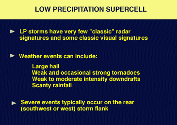
Low-precipitation supercells probably rarely occur, if at all, east of the Mississippi River. They frequently produce large hail, funnel clouds, and wall clouds, and occasionally spawn weak or even strong tornadoes. Radar identification of the storm as a supercell is difficult, especially at great range, because of the relatively small size and dry nature of the storm. Similar to the classic supercell, but unlike the HP storm, severe weather usually occurs in the southwest quadrant of the LP storm.
One last point of discussion for radar operators: spotters may report very wild visual sights and large hail with one of these storms while radar shows very little. Diplomacy, not disbelief, is important, for if you work severe weather in Texas, Oklahoma, Kansas, Nebraska, the Dakotas, or eastern portions of Colorado and Wyoming, you will encounter the LP supercell sooner or later.
|
HP Supercells |
|
with tornado |