|
|
. |
Warm Advection
warm air moves into a cooler region
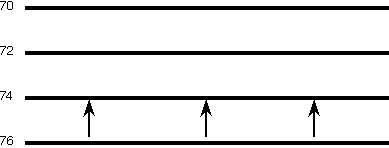
Warm advection is the process in which the wind blows from a region of warm
air to a region of cooler air. The following animation depicts a very simple
example of warm advection. The horizontal lines are isotherms in
degrees Fahrenheit and the arrows represent
wind vectors.
Winds are blowing from a region of warm air to a region of colder air,
which results in a warming of the colder region.
As the warm advection persists, temperatures in the colder
region will begin to increase as the warmer air moves into the region
of colder air.
Animation by:
Van Dorn
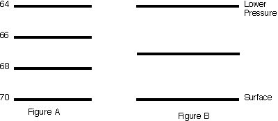
The net result of warm advection is to make a
region warmer. The animation below shows (in a very general sense) how warm
advection can produce upward motion.
Warm advection is occurring in Figure A
while Figure B shows a vertical cross section through the region of
warm advection.
It is important to
realize that Figure A is along the ground and that Figure B is from the ground
up to a higher level in the atmosphere, directly over the region of
warm advection.
Animation by:
Van Dorn
With the onset of warm advection (Figure A), the
isobar in
Figure B starts to bend upward since
warmer air is less dense and occupies
more space than colder air.
The bending of the isobar
due to warm advection creates a localized area of
high pressure ("H" in Figure B), thus altering the
pressure
gradient force. As air moves from the local region of
high pressure to the regions of
lower pressure ("L" in Figure B), air is drawn
upward from below, which is the rising motion produced by warm advection.

cold advection
|
|

850 temp advection
|
|