WW2010
University of Illinois

WW2010
 
  welcome
 
> online guides
 
  archives
 
  educational cd-rom
 
  current weather
 
  about ww2010
 
  index

Online Guides
 
  introduction
 
> meteorology
 
  remote sensing
 
  reading maps
 
  projects, activities

Meteorology
 
  introduction
 
  air masses, fronts
 
  clouds, precipitation
 
  el nino
 
  forces, winds
 
  hurricanes
 
  hydrologic cycle
 
  light, optics
 
  midlatitude cyclones
 
  severe storms
 
> weather forecasting

Weather Forecasting
 
  introduction
 
  methods
 
> surface features
 
  temperatures
 
  precipitation

Surface Features
 
> anticyclones
 
  cyclones
 
  cold fronts
 
  warm fronts
 
  stationary fronts
 
  occluded fronts
 
  dry lines

User Interface
 
  graphics
> text

NOTE: We've guessed that you're not using a client that supports colored tables and have tried to compensate. Low graphics mode looks much better on clients that do... we recommend switching to Netscape 3.0 or Microsoft Internet Explorer.
.
Anticyclones
bringing fairer weather

There are several key surface features to consider when making a forecast. We will begin this discussion with the anticyclone, which is a high pressure center where the pressure has been measured to be the highest relative to its surroundings. That means, moving any direction away from the "High" will result in a decrease in pressure. High pressure centers often represent the centers of anticyclones.

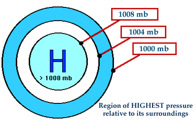
A high pressure center is represented on a weather map by a blue "H" and air diverges outward from a surface high. With air moving away from this region, air must sink from above to replace it. This sinking motion leads to generally fair skies and no precipitation near the high.

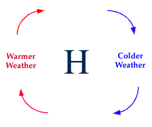
Winds flow clockwise around a high pressure center in the northern hemisphere (above). Temperatures are dependent upon the location relative to the high. Northerly winds associated with an approaching high are likely to result in colder temperatures while southerly winds found on the backside of a high, or once a high has passed through, typically result in a warming trend.


Methods
Terms for using data resources. CD-ROM available.
Credits and Acknowledgments for WW2010.
Department of Atmospheric Sciences (DAS) at
the University of Illinois at Urbana-Champaign.

cyclones