Researchers continue to investigate possible interactions between hurricane frequency and El Niño. El Niño is a phenomenon where ocean surface temperatures become warmer than normal in the equatorial Pacific. (The chart below shows the anomaly associated with the most recent El Niño in 1997-1998.) In general, warm El Niño events are characterized by more tropical storms and hurricanes in the eastern Pacific and a decrease in the Atlantic, Gulf of Mexico and the Caribbean Sea.
![[Image: (52K)]](/guides/mtr/hurr/gifs/enso1.gif)
Image courtesy of CPC ENSO Main Page
The 1997-98 El Niño event agreed with this theory. In 1997, the Atlantic Ocean had 7 named storms, of which 3 became hurricanes and only one of them intense. Each of these figures were below average yearly values. The average hurricane season is compared against the average El Niño season below.
| Atlantic | Eastern Pacific | |||
|---|---|---|---|---|
| Average | El Niño Avg. | Average | El Niño Avg. | |
| Named storms | 9.4 | 7.1 | 16,7 | 17.6 |
| Hurricanes | 5.8 | 4.0 | 9.8 | 10.0 |
| Intense Hurricanes | 2.5 | 1.5 | 4.8 | 5.5 |
The primary explanation for the decline in hurricane frequency during El Niño years is due to the increased wind shear in the environment.
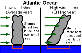
In El Niño years, the wind patterns are aligned in such a way that the vertical wind shear is increased over the Caribbean and Atlantic. The increased wind shear helps to prevent tropical disturbances from developing into hurricanes. In the eastern Pacific, the wind patterns are altered in such a way to reduce the wind shear in the atmosphere, contributing to more storms.
|
global activity |
|
Hydrologic Cycle |