WW2010
University of Illinois

WW2010
 
  welcome
 
> online guides
 
  archives
 
  educational cd-rom
 
  current weather
 
  about ww2010
 
  index

Online Guides
 
  introduction
 
  meteorology
 
> remote sensing
 
  reading maps
 
  projects, activities

Remote Sensing
 
  introduction
 
> radars
 
  satellites

Radars
 
  introduction
 
> radar basics
 
  imagery
 
  velocity patterns
 
  applications

Radar Basics
 
  radar signals
 
  wave properties
 
  signal scattering
 
  wavelength effects
 
  ray paths
 
  clear air returns
 
  target location
 
> scanning modes
 
  radial velocity

User Interface
 
  graphics
> text

NOTE: We've guessed that you're not using a client that supports colored tables and have tried to compensate. Low graphics mode looks much better on clients that do... we recommend switching to Netscape 3.0 or Microsoft Internet Explorer.
.
Scanning Modes
PPI and RHI

The two main types of scans used in meteorology are the Plan Position Indicator (PPI) and the Range Height Indicator (RHI) scans.
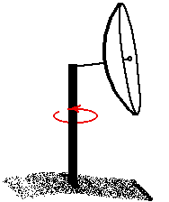
Plan Position Indicator (PPI):
When scanning in PPI mode, the radar holds its elevation angle constant but varies its azimuth angle. The returns can then be mapped on a horizontal plane. If the radar rotates through 360 degrees, the scan is called a "surveillance scan". If the radar rotates through less than 360 degrees, the scan is called a "sector scan".
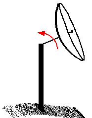
Range Height Indicator (RHI):
When scanning in RHI mode, the radar holds its azimuth angle constant but varies its elevation angle. The returns can then be mapped on a vertical plane. The elevation angle normally is rotated from near the horizon to near the zenith (the point in the sky directly overhead).


target location
Terms for using data resources. CD-ROM available.
Credits and Acknowledgments for WW2010.
Department of Atmospheric Sciences (DAS) at
the University of Illinois at Urbana-Champaign.

radial velocity