|
|
. |
Multicell Cluster Storms
a cluster of storms in varying stages of development
A multicell cluster consists of a group of cells moving as a single unit,
with each cell in a different stage of the thunderstorm life cycle. As
the multicell cluster evolves, individual cells take turns at being the
most dominant. New cells tend to form along the upwind (typically
western or southwestern) edge of the cluster, with mature cells
located at the center and dissipating cells found along the downwind
(east or northeast) portion of the cluster.
Multicell cluster storms frequently
look similar to the one pictured in the photograph below, (assuming that
low visibilities and/or intervening
clouds, trees, or hills do not obscure
the view). Looking north from about
10 miles, note the three distinct updraft
towers at the left (west) portion of
the storm. The heaviest precipitation
likely falls beneath the highest cloud top.
The right
(east) side of the complex is dominated
by anvil outflow, moving with the storm
from left to right.
[Image: mulicell cluster over an open field (51K)]
Photograph by:
Moller
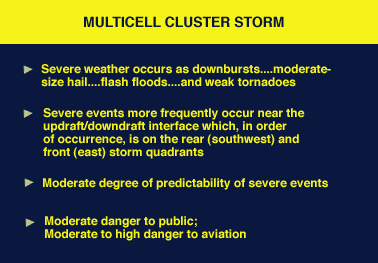
Multicell severe weather can be of any variety, and generally these
storms are more potent than single cell storms,
but considerably less so than
supercells.
Organized multicell storms have the higher severe weather
potential, although unorganized multicells, which are simply conglomerates of
single cells, can produce pulse storm-like bursts of severe events.
Actually,
the distinction between multicell and
single cell storms is not nearly as
important as that between multicells and
supercells.
The multicell flash flood threat can be significant,
in fact most flash floods
probably occur with multicell complexes. As with all thunderstorms, the threat
to the aviation community is quite high.

Single Cell Storms
|
|

components
|
|
![[Image: mulicell cluster over an open field (51K)]](/guides/mtr/svr/type/clstr/gifs/home1.gif)