|
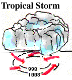
Once a tropical depression has intensified to the point where its maximum sustained winds are between 35-64 knots (39-73 mph), it becomes a tropical storm. It is at this time that it is assigned a name. During this time, the storm itself becomes more organized and begins to become more circular in shape -- resembling a hurricane. |
The rotation of a tropical storm is more recognizable than for a tropical depression. Tropical storms can cause a lot of problems even without becoming a hurricane. However, most of the problems a tropical storm cause stem from heavy rainfall.
![[Image: (87K)]](/guides/mtr/hurr/stages/gifs/ts2.gif)
Image by: OSEI
The above satellite image is of tropical storm Charlie (1998). Many cities in southern Texas reported heavy rainfall between 5-10 inches. Included in these was Del Rio, where more than 17 inches fell in just one day, forcing people from their homes and killing half a dozen.
|
tropical depression |
|
Hurricanes |