|
|
. |
CISK
how thunderstorms become hurricanes
CISK, or "Convective Instability of the Second Kind", is a popular
theory that explains how
thunderstorms can evolve and organize into
hurricanes. CISK is a positive feedback
mechanism, meaning that once a process starts, it causes events which
enhance the original process, and the whole cycle
repeats itself over and over.
Below is a video explanation of CISK.
[Embedded Object: CISK Movie (2.40MB)]
|
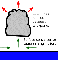
The surface air that
spirals into the center of a
low pressure system creates
convergence (green horizontal arrows)
and forces air to rise
in the center (green vertical arrow). This air cools and moisture
condenses
which releases latent heat into the air. It is this latent heat that
provides the energy to fuel these storms.
|
|
Latent heat is simply heat released or absorbed by a substance (in this
case, water vapor) as it changes its state. When water vapor condenses
into liquid, it releases this heat into the surrounding atmosphere. The
atmosphere around this condensation then warms.
Since warm air is less dense than cooler air, the warmer air
takes up more space. This expansion of this air (red arrows) forces
more air outside away from the center of the storm and the surface
pressure (which is the weight of the air above the surface) decreases.

|
When the surface pressure decreases, a larger
pressure gradient is formed, and more air
converges towards the center of
the storm. This creates more surface convergence and causes more
warm moist surface air to rise above the surface. This air, as it
cools, condenses into clouds. While it does
this, it releases even more latent heat.
This cycle continuously repeats itself Ł each time intensifying
the storm until other factors, such as
cool water, land, or
high wind shear act to weaken it.
|

sources
|
|

Development Stages
|
|