|
|
. |
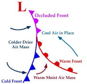
Occluded Front
when a cold front overtakes a warm front
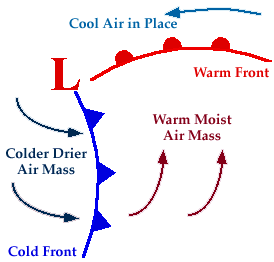
A developing cyclone typically has a preceding
warm front (the leading
edge of a warm moist air mass)
and a faster moving
cold front
(the leading edge of a colder drier air mass
wrapping around the storm). North of the
warm front is a mass of cooler air that was in place before the
storm even entered the region.
As the storm intensifies, the
cold front
rotates around the storm and catches the
warm front. This forms
an occluded front, which is the boundary that
separates the new cold air mass (to the west) from the older cool air
mass already in place north of the warm front.
Symbolically, an occluded front is represented by a solid line with
alternating triangles and circles pointing the direction the front is
moving. On colored weather maps, an occluded front is drawn with a
solid purple line.
Changes in temperature, dew point temperature,
and wind direction can occur with the
passage of an occluded front.
In the map below,
temperatures ahead (east of) the front
were reported in the low 40's while temperatures behind (west of)
the front were in the 20's
and 30's.
The lower dew point temperatures behind the front
indicate the presence of drier air.
[Image: occluded front on weather map (26K)]
Image by:
WXP Purdue
A noticeable
wind shift also occurred
across the occluded front. East of the front, winds were reported
from the east-southeast
while behind the front, winds were from the west-southwest.
Common characteristics associated with occluded fronts
have been listed in the table below.
|
|
Before Passing |
|
While Passing |
|
After Passing |
| Winds |
|
southeast-south |
|
variable |
|
west to northwest |
Temperature
Cold Type
Warm Type |
|
cold-cool
cold |
|
dropping
rising |
|
colder
milder |
| Pressure |
|
usually falling |
|
low point |
|
usually rising |
| Clouds |
|
in order: Ci,
Cs, As, Ns |
|
Ns, sometimes Tcu and
Cb |
|
Ns, As or scattered
Cu |
|---|
| Precipitation |
|
light, moderate or heavy precipitation |
|
light, moderate or heavy continuous precipitation or
showers |
|
light-to-moderate precipitation followed by general
clearing |
| Visibility |
|
poor in precipitation |
|
poor in precipitation |
|
improving |
|---|
| Dew Point |
|
steady |
|
usually slight drop, especially if cold-occluded |
|
slight drop, although may rise a bit if warm-occluded |
Table adapted from:
Ahrens, (1994)

Warm Front
|
|

dry line
|
|
![[Image: occluded front on weather map (26K)]](/guides/mtr/af/frnts/gifs/ofdef3.gif)