|
|
. |
Stationary Front
a front that is not moving
When a warm or cold
front stops moving, it becomes a stationary front. Once this boundary resumes
its forward motion, it once again becomes a
warm front
or cold front.
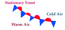
A stationary front is represented by alternating
blue and red lines with blue triangles pointing towards the warmer air
and red semicircles pointing towards the colder air.
A noticeable temperature change and/or shift in wind direction is commonly
observed when crossing from one side of a stationary front to the other.
[Image: surface map with analyzed stationary front (47K)]
Image by:
WXP Purdue
In the map above,
temperatures south of the stationary front were in the
50's and 60's with
winds
generally from the southeast. However,
north of the stationary front, temperatures
were in the 40's while the winds
had shifted around to the northeast.
Cyclones migrating along a stationary front
can dump heavy amounts of precipitation, resulting in significant
flooding along the front.

introduction
|
|

Cold Front
|
|
![[Image: surface map with analyzed stationary front (47K)]](/guides/mtr/af/frnts/gifs/sfdef2.gif)