WW2010
University of Illinois

WW2010
 
welcome
 
online guides
 
archives
 
educational cd-rom
 
current weather
 
about ww2010
 
index

Online Guides
 
introduction
 
meteorology
 
remote sensing
 
reading maps
 
projects, activities

Meteorology
 
introduction
 
air masses, fronts
 
clouds, precipitation
 
el nino
 
forces, winds
 
hurricanes
 
hydrologic cycle
 
light, optics
 
midlatitude cyclones
 
severe storms
 
weather forecasting

Forces, Winds
 
introduction
 
pressure
 
pressure gradient
 
coriolis force
 
geostrophic wind
 
gradient wind
 
friction
 
boundary layer wind
 
sea breezes
 
land breezes

Pressure
 
definition
 
variation with height
 
isobars
 
pressure surfaces
 
variation with temps
 
high pressure center
 
low pressure center

User Interface
 
graphics
text

.
Low Pressure Centers
also known as cyclones

A low pressure center is where the pressure has been measured to be the lowest relative to its surroundings. That means, moving in any horizontal direction away from the "Low" will result in an increase in pressure. Low pressure centers also represent the centers of cyclones.

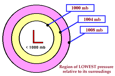
A low pressure center is indicated on a weather map by a red "L" and winds flow counterclockwise around a low in the northern hemisphere. The opposite is true in the southern hemisphere, where winds flow clockwise around an area of low pressure.

[Image: low pressure animation (53K)]
Animation by: Hall

Rising motion in the vicinity of a low pressure center favors the development of clouds and precipitation, which is why cloudy weather (and likely precipitation) are commonly associated with an area of low pressure.


high pressure center
Terms for using data resources. CD-ROM available.
Credits and Acknowledgments for WW2010.
Department of Atmospheric Sciences (DAS) at
the University of Illinois at Urbana-Champaign.

Forces, Winds