|
|
. |
Finding Warm Fronts Using Dew Points
higher dew point temperatures behind the warm front
Another indication of a possible frontal passage is a change in the air's
relative humidity.
The air mass behind a warm front
is typically more moist than the air mass ahead of the front.
The surface map below contains reports of
temperature,
dew point temperature,
and wind barbs.
Higher dew points indicate a higher moisture content of the air.
Ahead of the warm front analyzed below, dew point temperatures were
generally in the 40's, while behind the front, dew point values climbed
into the 50's.
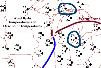
This increase in dew point temperature
indicated that the air behind the
warm front contained more moisture.
A noticeable change in the air's
relative humidity is commonly observed with the
passage of a warm front. Before the front arrives, the air typically feels
less humid than after the warm front passes through.

wind shift
|
|

cyclones
|
|