|
|
. |
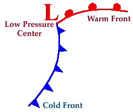
Cyclones and Associated Cold Front
leading edge of colder air mass
Below is a simple model of a cyclone with a
cold front extending to the south from the
center of low pressure and
a warm front extending to the east
ahead of the storm.
At low levels, several air masses
of distinctly different origin may be
found in varying parts of the cyclone.
The cold front marks the leading edge of a
colder and
drier air mass being wrapped southeastward by
north-northwesterly winds behind
the low.
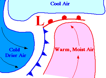
Clouds and
precipitation usually develop along
and ahead of the cold front as the colder air mass
lifts the warm moist air ahead of it.

lower dew points
|
|

precipitation
|
|