|
Precipitation Type and Tendencies
what it is and where it's moving
The type of weather associated with a
cluster of radar echoes is identified
by letter abbreviations.
A table of the common
weather symbols has been given below:
| Tornado |
written out |
|
Freezing Drizzle |
ZL |
| Waterspout |
written out |
|
Ice Pellets |
IP |
| Funnel Cloud |
written out |
|
Ice Pellet Showers |
IPW |
| Severe Thunderstorm |
T+ |
|
Snow |
ZL |
| Thunderstorm |
T |
|
Snow Showers |
SW |
| Rain |
R |
|
Snow Pellets |
SP |
| Rain Showers |
RW |
|
Snow Grains |
SG |
| Freezing Rain |
ZR |
|
Ice Crystals |
IC |
| Drizzle |
L |
|
Hail |
A |
These abbreviations
appear as small white letters.
For example, RW was reported in eastern Texas, which
indicates "rain showers".
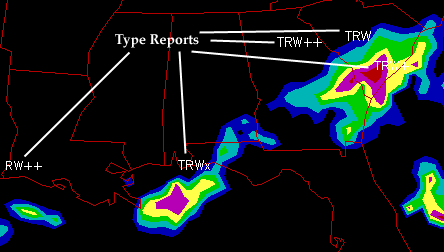
However, many of these reports are
combinations of two or more abbreviations as
in South Carolina, where "TRW" was near the yellow and green
radar echoes.
"TRW" is a combination of "T"
(thunderstorms), "RW" (rain showers) and
actually means showers and thunderstorms.
Further west in northern Georgia, a "TRW++" was reported
near the pink and red radar echoes, which indicates the presence
of showers and severe thunderstorms in the area. The extra "+"
is there to emphasize that these are very intense
storms.
Precipitation tendency indicates a change of the
intensity of precipitation during the last time period.
This information
is represented
by either a white "NC", "+", or a "-".
The "NC" reported in the panhandle of Florida, indicates that
the intensity of the precipitation during the past hour has
"Not Changed".
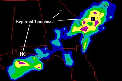
In Georgia a "-"
reported, which means that the intensity of precipitation
has decreased.
This makes sense because
the line of heavier precipitation (indicated by the yellow, pink
and red radar echoes), was moving out of
Georgia and into South Carolina.
This also explains why there
was a "+" indicated in South Carolina, where
the intensity of the precipitation is on the increase,
due to the
heavier showers and thunderstorms approaching from the west.
|