Jet streaks are important as they are indicative of rising motion/falling pressures at the surface. The figure below represents an idealized jet streak.
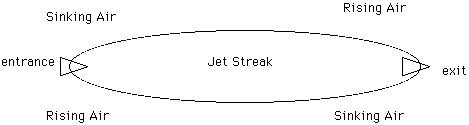
As air enters from the left, it must be accelerated. The force to do this is supplied by the Coriolis force as air flows from the south to the north near the jet entrance, leading to a force to the east (the right). This air motion results in a convergence to the north and a divergence to the south. As a result, air sinks in the northern 'quadrant', and rises in the southern quadrant, leading to pressure changes at the surface. In the jet exit region, the opposite happens, as air flows from north to south to create the force necessary to decelerate the air as it leave the jet streak. The vertical motion resulting from this leads to rising air in the north quadrant and sinking air in the south, also leading to surface pressure changes. Look at this 300mb map for 12Z, April 6,1997.
![[Image: (45K)]](/guides/mtr/cyc/upa/gifs/vrt2.gif)
Notice the jet streak that lies along the southeastern U.S. Now look at the following surface pressure plots.
![[Image: (56K)]](/guides/mtr/cyc/upa/gifs/vrt3.gif)
![[Image: (51K)]](/guides/mtr/cyc/upa/gifs/vrt4.gif)
Notice how pressures have risen below the north entrance region, and fallen below the north exit region. This will intensify cyclones which tend to be located below the north exit quadrant.
|
jet streaks |
|
mid-level moisture |