![[Image: Hydrologic Animation (318K)]](/guides/mtr/hyd/gifs/smry1.gif)
Animation by: Bramer
The hydrologic cycle begins with the evaporation of water from the surface of the ocean. As moist air is lifted, it cools and water vapor condenses to form clouds. Moisture is transported around the globe until it returns to the surface as precipitation. Once the water reaches the ground, one of two processes may occur; 1) some of the water may evaporate back into the atmosphere or 2) the water may penetrate the surface and become groundwater. Groundwater either seeps its way to into the oceans, rivers, and streams, or is released back into the atmosphere through transpiration. The balance of water that remains on the earth's surface is runoff, which empties into lakes, rivers and streams and is carried back to the oceans, where the cycle begins again.
Lake effect snowfall is good example of the hydrologic cycle at work. Below is a vertical cross-section summarizing the processes of the hydrologic cycle that contribute to the production of lake effect snow. The cycle begins as cold winds (horizontal blue arrows) blow across a large lake, a phenomena that occurs frequently in the late fall and winter months around the Great Lakes.
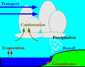 |
Evaporation of warm surface water increases the amount of moisture in the colder, drier air flowing immediately above the lake surface. With continued evaporation, water vapor in the cold air condenses to form ice-crystal clouds, which are transported toward shore. |
By the time these clouds reach the shoreline, they are filled with snowflakes too large to remain suspended in the air and consequently, they fall along the shoreline as precipitation. The intensity of lake effect snowfall can be enhanced by additional lifting due to the topographical features (hills) along the shoreline. Once the snow begins to melt, the water is either absorbed by the ground and becomes groundwater, or goes returns back to the lake as runoff.
Lake effect snow events can produce tremendous amounts of snow. One such event was the Cleveland, Ohio Veteran's Day Snowstorm from November of 1996, where local storm snowfall totals exceeded 50 inches over two to three days.
|
runoff |
|
Light, Optics |