|
Interpreting Weather Symbols
scaffolding activity
Introduction:
In addition to temperature, dew point temperature, cloud cover, pressure
and wind observations, a surface observation symbol also reports the
current weather through the weather symbol. Conditions for clear skies,
rain, snow and fog have appropriate symbols which are displayed as needed for
each station report.
The purpose of this activity is to introduce the most common weather
symbols and how to interpret current weather conditions for cities on a
map of surface observations. Key words
throughout this activity link directly to helper resources that provide
useful information for answering the questions.
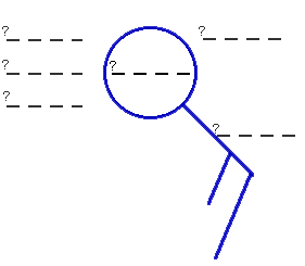
Location of Weather Symbol:
1) Fill in the blanks of the diagram to indicate what type of
meteorological data is represented by each position.
Then circle the position of the weather symbol.
You may label the diagram
in one of two ways; 1) by printing out a copy of this activity and marking your
answers directly onto the printout or 2) by saving the image into your favorite
graphics software and modifying the image using that graphics package.
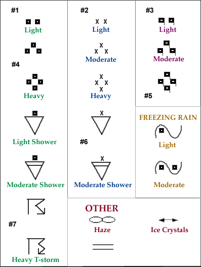
Common Weather Symbols:
2) For the following table of common
weather symbols,
fill in the blanks labeled #1 through #7.
You may label the diagram
in one of two ways; 1) by printing out a copy of this activity and marking your
answers directly onto the printout or 2) by saving the image into your favorite
graphics software and modifying the image using that graphics package.
Reporting Weather Conditions:
3) Below is a map of surface observations, and for each station that
used a weather symbol in the station report,
give the name of the city and the type
of weather reported at that time. For each type of precipitation identified,
indicate its intensity (whether its light, moderate or heavy).
There are a total of 11 cities for which this data must be recorded.
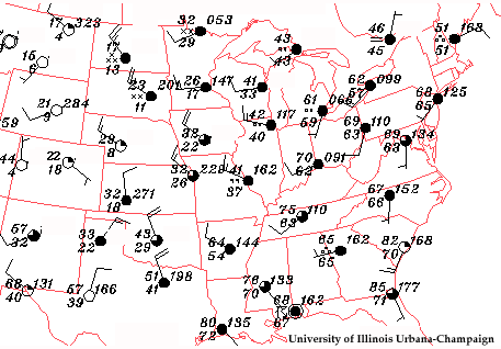
Example: #1: Bismark, ND -- Moderate Snow
Reporting Current Weather Conditions:
4) Now apply what you have learned to real-time weather data. Go to the
Weather Visualizer
(
CoVis
version |
public
version),
create the latest map of surface observations. From
this map, report the current weather (weather symbol)
for each station you identified in question #3. If no symbol was given, then
simply write, "No Significant Weather".
If the Weather Visualizer is too busy, here are additional web
sites for accessing current weather data.

observation symbols
|
|

forecasting temps
|
|