|
Microbursts
downburst less than 2.5 miles in diameter
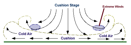
A downburst is a strong downdraft which includes an outburst of
potentially damaging winds on or near the ground. If the diameter of the
downburst is less than 2.5 miles, it is called a microburst. The diagrams
below depict the evolution of a microburst.
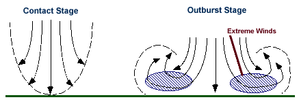
A microburst
initially develops as the downdraft begins its descent from cloud base. The
downdraft accelerates and within minutes, reaches the ground (contact stage).
It is during the contact stage that the highest winds are observed.
During the outburst stage (above), the wind "curls" as the cold air
of the microburst moves away from the point of impact with the ground.
During the cushion stage, winds about the curl continue to accelerate,
posing a great threat to nearby aircraft.
These are very weak, high based showers
without thunder, but with microbursts.
Studies have shown that they predominantly occur in the High Plains
and western U.S.: particularly in unstable, very dry low level
environments with surface temperature-dew point spreads of 30 to 50
degrees and an area of mid-level moisture as a source for the weak showers.
[Image: virga trail indicating microburst (63K)]
Photograph by:
Moller
The cloud on the left is developing, whereas the fuzzy anvil on the right
has matured and is producing a trail of virga.
Microbursts would be most
likely to occur beneath the virga,
when the downdraft reaches the ground.
Several of these virga
showers did produce microbursts in the Lubbock,
Texas area.
[Image: blowing dust resulting from microburst (55K)]
Photograph by:
Moller
The same day, near the Lubbock Airport, we see several of the
small microbursts which emanated from the virga patch in the
upper right corner of the photograph. Wind shifts of 35 to 40
MPH were noted shortly after this time, with a rapid onset
and cessation of the wind gusts.

gust fronts
|
|

anatomy
|
|
![[Image: virga trail indicating microburst (63K)]](/guides/mtr/svr/comp/out/micro/gifs/home3.gif)
![[Image: blowing dust resulting from microburst (55K)]](/guides/mtr/svr/comp/out/micro/gifs/home4.gif)