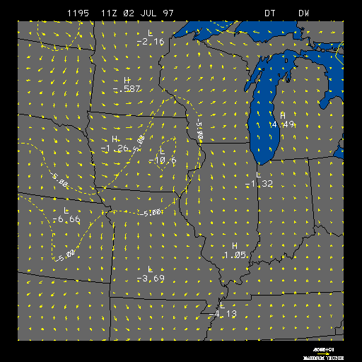
Example Surface 3 Hour Temperature and Wind Change
This is the Surface 3 Hour Temperature and Wind Change image, and on this
image are areas of 3 hour positive and negative temperature change, plus 3
hour wind changes. This images is useful for locating the position of
fronts
Positive temperature change areas are contoured in solid yellow lines and indicate that the temperature is rising in that region. Negative temperature change areas are contoured in dashed yellow lines and indicate that the temperature is falling in that region. Both temperature change areas are contoured in intervals of 5 degrees Fahrenheit. Therefore, a positive temperature change contour of 5 would indicate that the temperature has risen by 5 degrees Fahrenheit in the past 3 hours within that contour.
The 3 hour wind change is represented by wind vectors in units of meters per second, as indicated by the length of each wind vector. The wind vectors also show the change in wind direction during the past 3 hours, as indicated by the direction the arrow is pointing. The length and magnitude of the strongest wind vector is shown in the lower right-hand corner.
This image is useful to locate the position of fronts
since fronts are boundaries of different air masses, and for warm
and cold fronts the air masses have different
temperature characteristics. Since there is typically
warm advection ahead of a cold front and
behind a warm front, positive temperature change regions could be found there.
Also, since there is typically cold advection
behind a cold front, negative temperature change regions could be found there.
The 3 hour wind change can help show the location of fronts, since one characteristic of both cold and warm fronts is a change in wind direction across the front.
The example image above shows an area of negative temperature change and an increase in the westerly winds located in Iowa. Both of these features are indications that a cold front has passed through the area.
|
3hr dew pt & wind |
|
3hr press & wind |