| Geostrophic winds exist in locations where there are no frictional forces and the isobars are striaght. However, such locations are quite rare. Isobars are almost always curved and are very rarely evenly spaced. This changes the geostrophic winds so that they are no longer geostrophic but are instead in gradient wind balance. They still blow parallel to the isobars, but are no longer balanced by only the pressure gradient and Coriolis forces, and do not have the same velocity as geostrophic winds. |
|
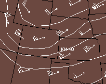
In the diagram below at point A, the parcel of air will move straight north. The pressure gradient and Coriolis forces are present, but when the isobars are curved, there is a third force -- the centrifugal force. This apparent force, pushes objects away from the center of a circle. The centrifugal force alters the original two-force balance and creates the non-geostrophic gradient wind.
| [Image: gradient wind around cyclone (50K)] | In this case, the centrifugal force acts in the same direction as the Coriolis force. As the parcel moves north, it moves slightly away from the center -- decreases the centrifugal force. The pressure gradient force becomes slightly more dominant and the parcel moves back to the original radius. This allows the gradient wind to blow parallel to the isobars. |
![[Image: gradient wind around cyclone (50K)]](/guides/mtr/fw/gifs/grad2.gif)
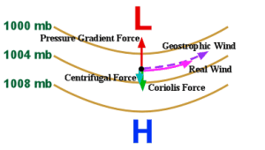
| Since the pressure gradient force doesn't change, and all the forces must balance, the Coriolis force becomes weaker. This in turn decreases the overall wind speed. This is where the gradient wind differs from the geostrophic winds. In this case of a low pressure system or trough, the gradient wind blows parallel to the isobars at a less than geostrophic (subgeostrophic) speed. |
|
| [Image: gradient wind around anticyclone (51K)] | This also applies to high-pressure systems as well. In this case, again starting from point A, the geostrophic wind will blow straight south. This time the centrifugal force is pushing in the same direction as the pressure gradient force, and when it gets slightly further away from the center, the centrifugal force again reduces, but this time that makes the Coriolis Force more dominant and the air parcel will move back to its original radius -- again with the end result being wind blowing parallel to the isobars. |
![[Image: gradient wind around anticyclone (51K)]](/guides/mtr/fw/gifs/grad4.gif)
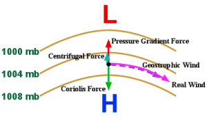
| Since the pressure gradient force still doesn't change, the Coriolis force must again adjust to balance the forces. However now it becomes stronger, which in turn increases the overall wind speed. This means that in a high pressure system or ridge, the gradient wind blows parallel to the isobars faster than geostrophic (supergeostrophic) speed. |
|
|
geostrophic wind |
|
friction |