|
Stationary Fronts
runway for cyclones
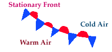
A stationary front
is simply a front that is not moving.
It is represented by alternating
blue and red lines with blue triangles pointing towards the warmer air
and red semicircles pointing towards the colder air.
Weather conditions greatly depend upon which side of the front a
location is positioned. If a stationary front is nearby and a
low pressure center is approaching
along the front, heavy amounts of precipitation are possible.
[Image: surface map with stationary front analyzed (47K)]
Image by:
WXP Purdue
There is usually a noticeable change in temperature and wind shift
crossing from one side of a stationary front to the other.
Low pressure
centers sometimes migrate along stationary fronts, dumping heavy amounts
of precipitation in their path. Such a scenario has been depicted above.
The alternating red and blue line is the stationary front and the blue and
green swatches indicate precipitation.

warm fronts
|
|

occluded fronts
|
|
![[Image: surface map with stationary front analyzed (47K)]](/guides/mtr/fcst/sfc/gifs/sfrnt2.gif)