An El Niño event is identified by warmer than normal sea surface temperatures (SSTs). An SST anomaly plot, like the one given below, shows the difference between the observed SSTs and the normal SSTs for a given month. This particular plot depicts the SST anomaly from December of 1982.
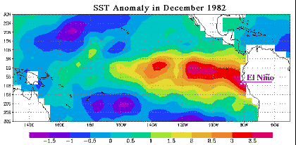
Image by: Liu
The yellow and red shadings of the eastern Pacific indicate that the waters were considerably warmer than normal. In fact, the El Niño event of 1982-83 was the strongest this century, with an SST anomaly exceeding 3.5 degrees Celsius.
![[Image: sst anomaly animation for 8/92 - 6/83 (88K)]](/guides/mtr/eln/gifs/sst3.gif)
[Image: color code bar ]
![[Image: color code bar ]](/guides/mtr/eln/gifs/sst4.gif)
Animation by: Liu
This animation depicts the SST anomaly field from the El Niño event of 1982-83 (August 1982 to June 1983). The yellows and reds in the eastern Pacific indicate the warming associated with the El-Niño event.
|
el nino events |
|
impacts on weather |