|
|
. |
Locating Tornadoes
hook echoes and velocity couplets
Tornadoes are often located at the center of
a hook-shaped echo on the southwest side of thunderstorms.
The hook is best observed in the reflectivity field.
This image shows a
reflectivity field containing several hook echoes associated with
thunderstorms that occurred in Tennessee and
Kentucky on May 18, 1995.
[Image: hook echoes in reflectivity field (34K)]
Another way to determine if a storm is tornadic
is to examine the radial velocity field.
A mesocyclone, the small rotating circulation with its center
beneath the updraft
of a supercell thunderstorm, is detectable as
a velocity couplet.
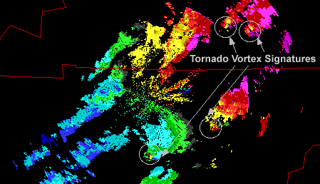
The couplet is oriented so that a concentrated area of radial winds moving
away from the radar appears on one side of the beam axis, while a
concentrated area of radial winds moving
toward the radar appears on the opposite side of the beam axis. When the
central pixels near the beam axis show exceptionally strong winds,
this signature is called
a tornado vortex signature (TVS).
This image shows the TVS in the velocity field from the same
Tennessee and Kentucky storms.
Negative values (blue-green) denote movement toward the radar and
positive values (yellow-red) represent
movement away from the radar.
[Image: hook echo new Newcastle (40K)]
Image provided by:
NSSL
Here is the reflectivity field from a storm which produced a tornado
in Texas on May 29, 1995.
The hook echo in the reflectivity field is located near Newcastle.
[Image: velocity couplet of Newcastle storm (55K)]
Image provided by:
NSSL
Here is the velocity couplet associated with the Newcastle hook echo (red
and green pixels adjacent to each other).

Velocity Patterns
|
|

hurricanes
|
|
![[Image: hook echoes in reflectivity field (34K)]](/guides/rs/rad/appl/gifs/trndo1.gif)
![[Image: hook echo new Newcastle (40K)]](/guides/rs/rad/appl/gifs/trndo3.gif)
![[Image: velocity couplet of Newcastle storm (55K)]](/guides/rs/rad/appl/gifs/trndo4.gif)