|
Jacksonville, Illinois Tornado
nexrad close-ups
Once the conditions appear favorable for the development of severe
weather, meteorologists turn their eyes to the skies and to the
radar screens.
The development of Doppler radar has greatly enhanced our ability to
see what goes on inside a severe thunderstorm.
More than a hundred Doppler radar sites are currently operational
around the United States.
Doppler radar plays a vital role in the prediction and detection of severe
weather, especially when the National Weather Service must determine
when and where to issue severe weather warnings.
This section provides a close-up examination of the radar signatures
associated with six of the tornadoes that occurred on April 19, 1996.
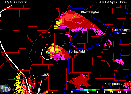
6:10pm CDT (4/19/96) -
LSX radar reflectivities show the hook echo associated with the tornadic
supercell near Jacksonville, Illinois.
Radar velocities show the mesocyclone embedded in the
Jacksonville supercell. The neighboring green and red pixels
are a likely indicator of
the mesocyclone circulation.

introduction
|
|

springfield
|
|
![[Image: (21K)]](/arch/cases/960419/nxrd/gifs/jack1.gif)