|
|
. |
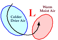
The Movement of Air Masses
transporting warm air northward and colder air southward
Counterclockwise winds associated with cyclones
transport
heat and moisture from lower to higher latitudes and play a
significant role in the movement of
air masses.
|
As a cyclone intensifies,
(the central pressure drops),
counterclockwise winds around the
low pressure center also intensify, transporting the
air masses around
the center of circulation.
|
By superimposing fronts over the
low pressure center and the
air masses,
a top view of a midlatitude cyclone and accompanying air masses
might resemble something like the diagram below:
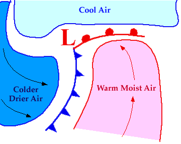
Southerly winds
east of the low transport warm and moist air northward and
this moisture often contributes to the
development of precipitation.
A warm front marks the leading edge
of this warm, moist air mass.
Behind the low, northerly
winds transport colder and drier air southward, with a
cold front marking the leading edge
of this colder, drier air mass.

associated winds
|
|

on satellite images
|
|