WW2010
University of Illinois

WW2010
 
welcome
 
online guides
 
archives
 
educational cd-rom
 
current weather
 
about ww2010
 
index

Online Guides
 
introduction
 
meteorology
 
remote sensing
 
reading maps
 
projects, activities

Meteorology
 
introduction
 
air masses, fronts
 
clouds, precipitation
 
el nino
 
forces, winds
 
hurricanes
 
hydrologic cycle
 
light, optics
 
midlatitude cyclones
 
severe storms
 
weather forecasting

Clouds, Precipitation
 
introduction
 
development
 
cloud types
 
precipitation

Precipitation
 
introduction
 
rain and hail
 
freezing rain
 
sleet
 
snow

Freezing Rain
 
introduction
 
definition
 
dangers
 
regions
 
processes
 
conditions
 
forecasting
 
sleet definition

User Interface
 
graphics
text

.
All about Sleet
It's slippery

Sleet is less prevalent than freezing rain and it is defined as fronzen raindrops that bounce on impact with the ground or other objects. Sleet is more difficult to forecast than freezing rain because it is formed under more specialized atmospheric conditions. It is very similar to freezing rain in that it causes surfaces to become very slick and causes automobile accidents and falls. It is also different in that it is not clear as glass and can be easily seen.

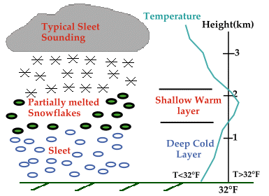
For sleet to fall the precipitation must begin as snow. Once the snow begins to fall it encounters a shallow layer of warm air and partially melts. The partially melted snow enters the deep cold layer it refreezes into an ice-pellet and becomes sleet.


Terms for using data resources. CD-ROM available.
Credits and Acknowledgments for WW2010.
Department of Atmospheric Sciences (DAS) at
the University of Illinois at Urbana-Champaign.