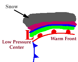
WW2010
University of Illinois

WW2010
 
welcome
 
online guides
 
archives
 
educational cd-rom
 
current weather
 
about ww2010
 
index

Online Guides
 
introduction
 
meteorology
 
remote sensing
 
reading maps
 
projects, activities

Meteorology
 
introduction
 
air masses, fronts
 
clouds, precipitation
 
el nino
 
forces, winds
 
hurricanes
 
hydrologic cycle
 
light, optics
 
midlatitude cyclones
 
severe storms
 
weather forecasting

Clouds, Precipitation
 
introduction
 
development
 
cloud types
 
precipitation

Precipitation
 
introduction
 
rain and hail
 
freezing rain
 
sleet
 
snow

User Interface
 
graphics
text

.
Snow
an aggregate of ice crystals

Progressing even further away from the warm front, surface temperatures continue to decrease and the sleet changes over to snow.

Snowflakes are simply aggregates of ice crystals that collect to each other as they fall toward the surface. The diagram below shows a typical temperature profile for snow with the red line indicating the atmosphere's temperature at any given altitude. The vertical line in the center of the diagram is the freezing line. Temperatures to the left of this line are below freezing, while temperatures to the right are above freezing.

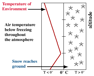
Since the snowflakes do not pass through a layer of air warm enough to cause them to melt, they remain in tact and reach the ground as snow.


sleet
Terms for using data resources. CD-ROM available.
Credits and Acknowledgments for WW2010.
Department of Atmospheric Sciences (DAS) at
the University of Illinois at Urbana-Champaign.

El Nino