Hurricanes are tropical cyclones with winds that exceed 64 knots (74 mi/hr) and blow counterclockwise about their centers in the Northern hemisphere, (clockwise in the Southern hemisphere).
|
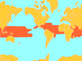
Hurricanes are born over the warm waters of the tropical oceans, where humid air and converging winds fuel convective processes responsible for developing hurricanes. |
![[Image: legend for above diagram ]](/guides/mtr/hurr/gifs/def3.gif)
Hurricane season typically extends from June through November, when water temperatures in these regions are relatively high (greater than 26.5 C). Most hurricanes occur in late summer and early fall, i.e., August and September. Hurricanes are larger than thunderstorms and tornadoes but smaller than mid-latitude cyclones The primary components of a hurricane include:
| [Image: (50K)] |
The Eye:
A region 20-50 km in diameter found at the center where skies are often clear, winds are light, and the storm's lowest pressure readings are obtained. Eye Wall:
Spiral Rainbands:
|
![[Image: (50K)]](/guides/mtr/hurr/gifs/def1.gif)
There is an average of 84 tropical storms and 45 hurricanes / typhoons globally per year. Roughly nine named storms develop per year in the tropical Atlantic and Gulf of Mexico, six of which typically become hurricanes; two of which become intense hurricanes (sustained winds exceeding 130 mph or 209 km/hr).
|
introduction |
|
how they're named |