
|


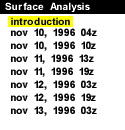
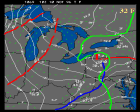
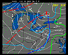
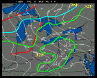
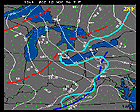
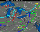
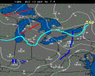
Surface weather maps for the Great Lakes region are analyzed in this section. Brian Jewett's MAP program was used for these images against the surface objective data from November 10-13. Selecting from the icons or table links will bring forth the analysis for the date selected.
 |
 |
 |
| 11/10/96 04z | 11/10/96 10z | 11/11/96 13z |
|---|---|---|
 |
 |
 |
| 11/11/96 19z | 11/12/96 03z | 11/12/96 19z |
 |
11/13/96 03z |
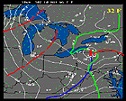
There are two maps shown for each time period. The first map shows pressure in solid white contours, temperature in dashed light green, and present weather in white lettering. Some present weather abbreviations:
- SW, RW: Snow showers, Rainshowers (- denotes light, + denotes heavy, no modifier denotes moderate)
- TS: Thunder snow
- R, S: Rain, Snow
- F: Fog - often seen in combination with R, S, especially if moderate or heavy
- H, K: Haze, Smoke obscuring visibility
The second map displays surface pressure in solid white contours and near surface wind vectors in light blue. The wind speed is related to the length of each vector; the longest vector in these images represents about 26 knots.
Some frontal positions, pressure centers and important isotherms are hand-drawn onto these maps. Note, that dashed red lines denote warm thermal troughs which are common in this type of lake effect snowstorm. Blue dashed lines represent a weakening or frontolytic cold front (in this case).
|
Upper Air Data |
|
Nov 10, 1996 04Z |