
|


By the early morning hours of Nov 11, 1996 heavy snow is falling in many of the snowbelt communities from western New York, NW Pennsylvania, and points west. Unseasonably cold air (note the low 20's in west central Ohio) is pouring into the region on brisk west and northwesterly flow. However, close to the warm lakes, surface temperatures warm as can be seen by following the 28F isotherm around Lake Erie and Ontario.
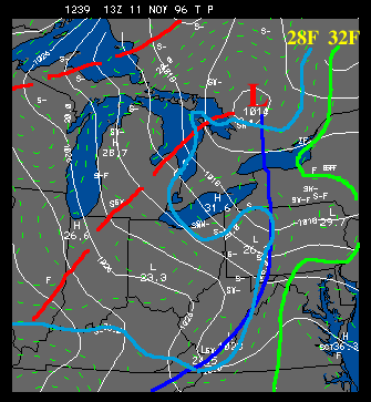 |
In the pressure field, the surface low responsible for the heavy snowfall of Saturday Nov 9 has lifted into Ontario Province and weakened. The associated cold front has made little progress eastward because the upper level trough is aligned with the surface front and does not provide any eastward push to the system. "thermal troughs" have set up east of Lakes Superior and Michigan. |
The flow field shows an ideal fetch for lake effect snow in NE Ohio and the downwind shore of Lake Erie. The fetch of cold air over southern Lake Michigan turns cyclonically from NW to westerly as it crosses the western end of Lake Erie.
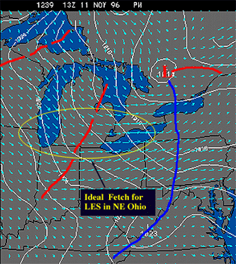 |
It appears that the thermal trough in evidence east of Lake Michigan is important in backing the flow between the two lakes. This trajectory across the two lakes implies that air arriving over Lake Erie will have been "preconditioned" with heat and moisture from Lake Michigan - thus, making it easier for clouds and precipitation to quickly form to the lee of the lakeshore. |
|
Nov 10, 1996 10Z |
|
Nov 11, 1996 19z |