
|


By Monday evening Nov 11 daytime temperatures have warmed nicely, as might be expected this early in the season. In fact, temperatures are above freezing throughout much of the eastern lakes. The thermal troughs in the western lakes persist, but are weaker because the contrast between the cold air flow and lake temperature is less - as a result of the daytime warming over the land.
 |
The lake effect snowfall is still widespread, but spotter reports indicate that the snowfall is more intermittent and not as heavy. Perhaps, the weakening of the thermal trough is partially responsible for the daily cycle of lake effect intensity seen in this storm. At the trough axis where winds change direction quickly, good convergence of air is likely - which helps support the development of lake squalls and snowbands. |
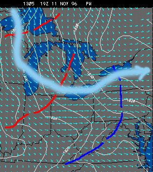 |
The flow field near the surface continues to show the persistent troughs downwind of the lakes, and a continuation of the multiple lake interactions. In particular, flow from Lake Superior to Lake Huron - to Lake Ontario is beginning to set up and squalls are increasing at the east end of Lake Ontario. |
|
Nov 11, 1996 13z |
|
Nov 12, 1996 03z |