|
A surface low in northwest Pennslvania (PA) is producing and area of snow and rain in the eastern lakes. The cold front associated with the low is the leading edge of the unseasonably cold air which set-off the LES event that persisted through the next three days.
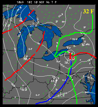 |
At 0400z on November 10 (i.e. late evening on the 9th of Nov), NE Ohio was receiving locally heavy snowfall as a result of the surface storm. At this hour snow was falling at the rate of 1-2"/hour in the higher elevations east and southeast of Cleveland, Ohio. Temperatures were hovering near freezing, as can be seen in the 32F isotherm highlighted below. Warmer air is being wrapped around the backside of the storm through the eastern lakes. |
Most accounts of this phase of the storm attributed the heavy snowfall in NE Ohio to the elevation of the terrain and the flow of unstable air over the east end of Lake Erie. Winds were weak in this area, but were both convergent and over water. This "lake-enhanced" snowfall produced a great variation of snowfall in the region. Some local snowfalls of 14" were reported in Geauga county, while nearby communities had only wet snow without accumulation. There is some question whether this was a "lake-enhanced" storm since the flow was quite weak and the air flowing over the open waters was not very cold. However, the lake temperature in eastern Lake Erie is very warm (>55F) so there is an appreciable difference between the water temperature and the air blowing across the lake. The distribution of snowfall certainly suggests lake-enhancement.
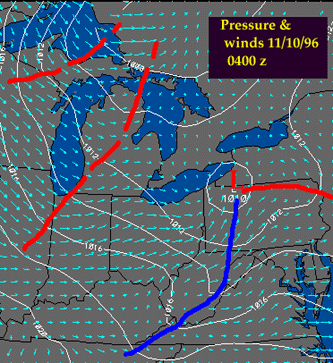 |
In the western lakes, much colder air is moving into upper Michigan and Wisconsin, and is setting off lake effect snow south of Lake Superior and east of Lake Michigan. The dotted red lines denote thermal troughs in the vicinity of the warm lakes. These troughs are important in redirecting air flow and creating surface convergence near and east of the trough axes. The troughs are found in most of the following surface analyses and remain fairly stationary throughout the duration of the storm. |

introduction |
|

Nov 10, 1996 10Z |
