
|


The images on this page are "slices" of the atmosphere sampled between different "upper air" stations. An upper air station is a weather service office (NWSFO) where a weather balloon or "radiosonde" is launched and tracked at least twice each day. The wind, height, temperature, and humidity data sent back to the tracking station - along with some satellite and aircraft reports - are the only continuous source of weather data above the surface. radiosonde data or soundings are crucial for every phase of weather forecasting and analysis - and of course, they are valuable in analyzing our Veteran's Day lake effect storm.
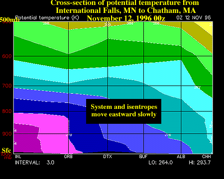
Our cross-section is produced by contouring lines of constant potential temperature or theta along a line from:
- International Falls, MN
- Green Bay, WI
- Detroit, MI
- Buffalo, NY
- Albany, NY
- Chatham, MA
This path or trajectory is chosen because it roughly follows the mean flow around the large trough in place during the storm. By looking at a cross-section of theta one can make judgments about the large-scale stability of the atmosphere, the movement of air masses, and the position of fronts, jet streaks (fast flowing cores of air in jet streams), and other large-scale features of the atmosphere.
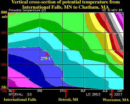
Cross-sections of theta displayed for each evening from November 10-12 at 00z, show the marked instability of the lower atmosphere across the slice trajectory. Theta contours with wide spacing between them denote low "static stability" which simply means that potential temperature is changing little with height. Near the surface, in the Great Lakes, the theta contours are nearly vertical - which indicates near-adiabatic conditions. Adiabatic or super-adiabatic layers (i.e. where the temperature cools with height at greater than or equal to 1 C / 100m ) are somewhat rare and are typically observed very close to the surface or are found in thin layers above the surface - under special atmospheric conditions. However, in the cross-section images from the Veteran's Day storm, widespread and deep layers of the atmosphere are found to be near-adiabatic which is quite surprising - and underscores the unusual nature of this storm. However, it should be pointed out that radiosonde observations are single points in time and space and one should be cautious in "connecting the dots" and drawing conclusions. For example, on November 11, 1997 at 00Z BUF shows little or no capping inversion below 550 mb while nearby Pittsburgh (PIT, not shown) shows a decent strength cap at about 750 mb - thus, our theta cross-sections would likely change considerably if other stations were included in the data.
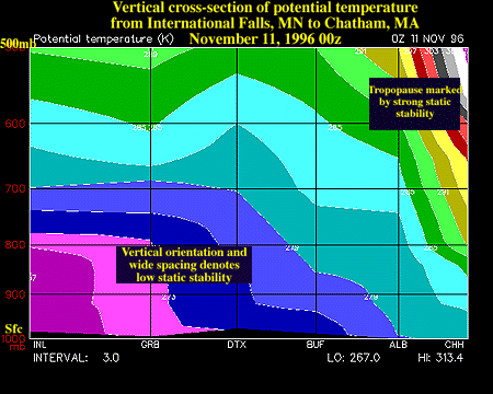
As time progresses, static stability does begin to increase from west to east. Notice the potential temperature contours above INL and GRB by Nov 12, 1996 at 00z. At about 750 mb, the contours are more horizontal with a tighter spacing in the vertical. This indicates the slow advection of dryer, warmer air aloft and undoubtedly marks the position of the capping inversion in the lower atmosphere that will eventually weaken the LES snowbands and squalls.
|
Soundings |
|
Surface Analysis |