
|


On the morning of November 12, 1996, snow showers and squalls are limited to the snowbelts of the eastern lakes with diminishing snows in the western lakes.
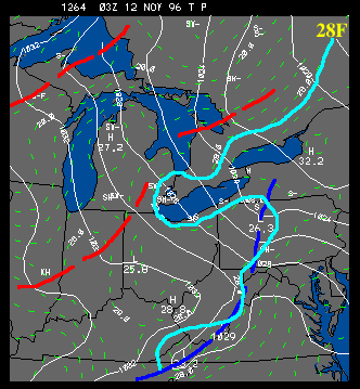 |
Temperatures are not quite as cold as the previous morning away from the lakes, but are colder near the lakes as the cold air mass becomes further entrenched in the region. The remains of the original polar front can still be detected along the spine of the Appalachians - note, the surface cold air never does make it to the east coast during this storm. |
The flow near the surface remains moderately strong during this time. Similar to other analyses, the flow changes direction quickly near the downwind shores of each lake. This is a result of the change in the surface roughness moving from the water to the land. The water is generally much smoother than the land surfaces - which means there is less frictional drag exerted upon the air flow. The net result of these forces deflects the wind to the left as the frictional drag increases.
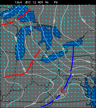 |
This can be seen very well near the south shore of Lake Erie. Winds over the land are mostly WSW while winds across the open waters are roughly westerly. Also notice that within the transition area from land to water there is convergence of air flow in the case of westerly flow - yet another mechanism for focusing convection and rising motions near the lakeshore. In the case of Lake Michigan the winds clearly back or turn to the left once they exit the open waters and flow over Lower Michigan. |
|
Nov 11, 1996 19z |
|
Nov 12, 1996 19z |