
|


The two main types of scans used in meteorology are the Plan Position Indicator (PPI) and the Range Height Indicator (RHI) scans.
|
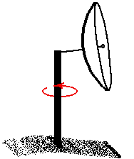
Plan Position Indicator (PPI):
When scanning in PPI mode, the radar holds its elevation angle constant but varies its azimuth angle. The returns can then be mapped on a horizontal plane. If the radar rotates through 360 degrees, the scan is called a "surveillance scan". If the radar rotates through less than 360 degrees, the scan is called a "sector scan". |
|
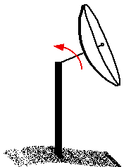
Range Height Indicator (RHI):
When scanning in RHI mode, the radar holds its azimuth angle constant but varies its elevation angle. The returns can then be mapped on a vertical plane. The elevation angle normally is rotated from near the horizon to near the zenith (the point in the sky directly overhead). |
|
target location |
|
radial velocity |