Hurricanes evolve through a life cycle of stages from birth to death. A disturbance graduates to a more intense stage of development by attaining a specified sustained wind speed.
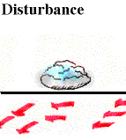 |
Tropical Disturbance:
The birth of a hurricane, having only a slight circulation with no closed isobars around an area of low pressure. Tropical disturbances commonly exist in the tropical trade winds at any one time and are often accompanied by clouds and precipitation. |
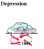 |
Tropical Depression:
If sustained winds increase to at least 20 knots, a disturbance is upgraded to a tropical depression. Surface wind speeds vary between 20 and 34 knots and a tropical depression has at least one closed isobar that accompanies a drop in pressure in the center of the storm. |
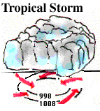 |
Tropical Storm:
If sustained wind speeds increase to at least 35 knots, a tropical depression is upgraded to a tropical storm. Surface wind speeds vary between 35 and 64 knots and the storm becomes more organized. Tropical storms resemble the appearance of hurricanes due to the intensified circulation. |
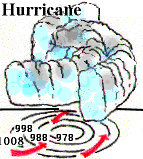 |
Hurricane:
As surface pressures continue to drop, a tropical storm becomes a hurricane when sustained wind speeds exceed 64 knots. A pronounced rotation develops around the central core as spiral rain bands rotate around the eye of the storm. The heaviest precipitation and strongest winds are associated with the eye wall. |
Watches and Warnings:
Modern technology provides forecasters with the ability to accurately
determine the position and intensity of hurricanes.
This information is used to provide advanced warnings to those
populations at risk. If it appears that a particular area is in potential danger
of being struck by a hurricane,
a "hurricane watch" is issued, sometimes up to several days in advance
of the storm's predicted arrival. When there is a high probability
that a hurricane will strike an area within 24 hours, a "hurricane
warning" is issued. Unfortunately, despite the advanced warning systems,
hurricanes still claim the lives of hundreds, even thousands of people
each year.
|
convective processes |
|
destruction |