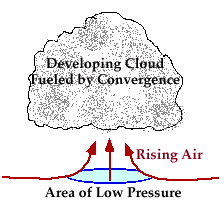
When the horizontal flow of air converges along the earth's surface, it must go somewhere. Since it is not able to go into the ground, it rises.
|
Large scale convergence lifts a layer of air (sometimes hundreds of kilometers across), the air cooling as it rises. If the rising air cools to its saturation point, the water vapor will condense out to form cloud droplets. |
| [Image: thickening cirrus and cirrostratus at sunset (65K)] |
Vertical motions associated with convergence lifting are typically much weaker than the stronger small scale vertical motions associated with convective processes. As a result, clouds generated through convergence are less vertically developed. Cirrostratus clouds is one cloud type that develops from convergence lifting. |
![[Image: thickening cirrus and cirrostratus at sunset (65K)]](/guides/mtr/cld/mch/gifs/cnvrg2.gif)
It is also important to note that convergence occurs not only at the surface, but higher levels as well.
|