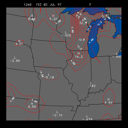
Example Surface Frontogenesis Image
This is the Surface Frontogenesis image, which is useful for finding areas
of positive and negative frontogenesis. The positive frontogenesis areas are
contoured in solid lines, and the negative frontogenesis areas are contoured
in dashed lines.
Frontogenesis is a measure of how the temperature gradient is changing with time, and the temperature gradient itself is a measure of how the temperature changes with distance. The units of frontogenesis are a little difficult to understand (they are degrees Fahrenheit per meter per second). Since computed frontogenesis values are so small, the frontogenesis values on this image are multiplied by a large number (10E10).
Frontogenesis is also the measure of how a front strengthens or weakens with time. Warm and cold fronts are boundaries between air masses of different temperature, which means there are temperature gradients (remembering that a temperature gradient is how the temperature changes with distance) across these fronts. The greater the temperature gradient are across a front, the stronger the front.
Positive frontogenesis means that the temperature gradient is increasing with time, and this also means that any front located in that region is also strengthening. If there are no fronts present near the location of the positive frontogenesis, then perhaps a new front will form if the frontogenesis is strong enough.
Therefore, one should not be overly concerned with the units of frontogenesis, but more importantly should consider the magnitude of frontogenesis and whether or not the frontogenesis is positive or negative. Where there are positive areas of frontogenesis, a front could be strengthening or forming, and while for negative areas of frontogenesis, a front could be weakening or dissipating.
The example image above shows an area of positive frontogenesis stretching from Wisconsin into Illinois. This particular front was a cold front.
|
3hr press & wind |
|
Upper Air Obs |