|
Updrafts/Downdrafts
rising and sinking air
All thunderstorms require instability (potential)
and lift.
The lift is the mechanism that releases the instability.
Lift is produced by such things as fronts
and low pressure troughs, or by air rising
upslope.
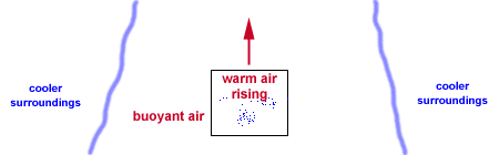
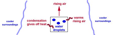
We say that the atmosphere is
unstable when air rising in a cloud is
warmer than its environment, like a hot-air
balloon.
It is the heat released by condensation within
a cloud that permits the rising air to stay
warmer than its surroundings, and thus to be
buoyant through great depths.
In the same way,
air that is cooler than its environment tends
to sink as long as it can stay cooler than its
surroundings. The upward moving air in a thunderstorm
is known as the updraft, while downward moving air is the downdraft.
The atmosphere can be unstable
for updrafts but stable for downdrafts, stable
for updrafts but unstable for downdrafts,
stable for both, or unstable for both.
The degree of atmospheric instability
is one of the two major factors in
determining the strengths of thunderstorm
updrafts and downdrafts. Furthermore,
vertical draft strengths basically
determine the degree of storm severity.
If we consider a "generic" storm, there
are four possible combinations of weak
and strong draft strengths.
[Image: draft strength combinations (46K)]
When the
low-level air is unstable but relatively
dry and adequate mid-level moisture is
present, a storm may develop with a weak
updraft but a strong downdraft with the
latter the result of strong negative
buoyancy and cooling through evaporation
of precipitation into the dry air.
This high-based storm resembles high
terrain, western U.S. storms which
occasionally produce dry microbursts.
Significant hail and rain are unlikely.
A storm which contains a strong updraft
and weak downdraft; will not produce wind
damage, but can foster heavy rains and/or
damaging hail. Single and
multicell storms
comprise this category. They include storms
that dump heavy rain, but little or no hail
because of warm conditions aloft, and multicell
storms that are capable of producing hail
because of lower environmental freezing levels.
Strong updraft, weak downdraft storms often form
in very moist atmospheres where there is little,
if any, dry air and evaporational cooling to drive downdrafts.
[Image: more updraft/downdraft combinations (48K)]
Relatively weak updrafts and downdrafts
are found with non-severe showers and
thunderstorms. The last possible combination
is a storm with strong updrafts and downdrafts.
These storms frequently produce destructive
downbursts, hail, heavy rain, and tornadoes.
As one would expect, the most severe storms,
including supercells, have strong vertical
drafts and occur in the most unstable atmospheres.

Tstorm Components
|
|

lemon techique (LT)
|
|
![[Image: draft strength combinations (46K)]](/guides/mtr/svr/comp/up/gifs/home3.gif)
![[Image: more updraft/downdraft combinations (48K)]](/guides/mtr/svr/comp/up/gifs/home4.gif)