|
|
. |
The Transport of Air Masses
bringing warm air northward and colder air southward
Cyclones play a crucial role in the earth's distribution of heat and
moisture. Counterclockwise winds associated with cyclones transport
large amounts of heat and moisture from lower to higher latitudes.
Think of the surface
winds around a center of low pressure
as the swirling waters of a whirlpool, where the water spins
around and towards the center.
A similar circulation is associated with a
midlatitude cyclone, where at the surface,
wind spin counterclockwise and inward towards the
center of low pressure.
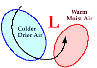
By superimposing fronts over the
low pressure center and the
air masses,
a top view of a midlatitude cyclone and accompanying air masses
might resemble something like the schematic diagram below:
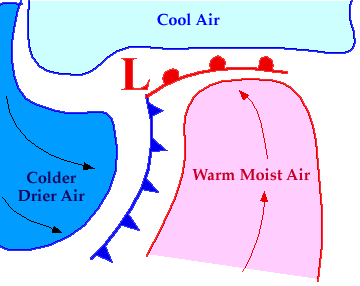
Southerly winds east of the low transport warm and moist air northward and
this moisture often contributes to the
development of precipitation.
A warm front marks the leading edge
of this air mass.
Behind the low, northerly
winds transport colder and drier air southward, with a
cold front marking the leading edge
of this air mass.
|