WW2010
University of Illinois

WW2010
 
  welcome
 
> online guides
 
  archives
 
  educational cd-rom
 
  current weather
 
  about ww2010
 
  index

Online Guides
 
  introduction
 
> meteorology
 
  remote sensing
 
  reading maps
 
  projects, activities

Meteorology
 
  introduction
 
  light & optics
 
  clouds, precipitation
 
> pressure module
 
  air masses & fronts
 
  weather forecasting
 
  severe storms
 
  hurricanes
 
  el nino

User Interface
 
  graphics
> text

NOTE: We've guessed that you're not using a client that supports colored tables and have tried to compensate. Low graphics mode looks much better on clients that do... we recommend switching to Netscape 3.0 or Microsoft Internet Explorer.
.
Winds Around Cyclones
flowing counterclockwise in the northern hemisphere

Wind barbs are a useful indicator for locating low pressure centers on surface weather maps.
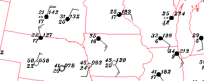

Since winds flow in a counterclockwise direction around low pressure centers, look for a group of stations where the wind barbs reflect this type of wind pattern. For example, a counterclockwise wind pattern was observed in the states of Nebraska, Iowa, Minnesota and South Dakota (highlighted by the red arrow).
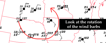

The low pressure center is located near the center (similar to the center of a whirlpool) with winds flowing counterclockwise around it.
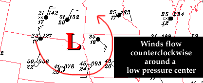

So when trying to find a low pressure center on a surface weather map, use the wind barbs to find a counterclockwise wind pattern and the low pressure center will be found near the center of circulation.


Terms for using data resources. CD-ROM available.
Credits and Acknowledgments for WW2010.
Department of Atmospheric Sciences (DAS) at
the University of Illinois at Urbana-Champaign.