|
|
. |
Orographic Clouds
forced by the earth's topography
Orographic clouds are clouds that develop in response to the forced lifting
of air by topographical features on the earth's surface, like
mountains for example.
[Image: lee mountain wave clouds (78K)]
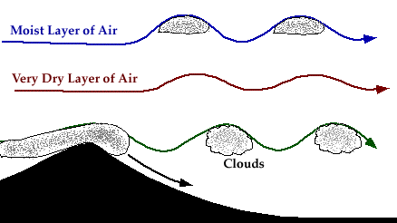
Air passing over a mountain will
oscillate up and down as it moves downstream (see diagram below).
Initially, stable air encounters a mountain and is lifted upwards.
The lifted air parcels
undergo cooling through expansion, and
eventually grow heavier than the surrounding air. If a parcel
cools to its
saturation point
during this process,
the water vapor within will condense and become visible as a cloud.

Upon reaching the mountain top, the air is heavier than the
environment and will sink down the other side, warming as it descends.
Once the air returns to its original height,
it has the same temperature and same buoyancy
as the surrounding air, but the air has momentum carrying it
downward and does not stop immediately.
With continued descent, the air becomes warmer than
the surroundings, and begins to accelerate back upwards towards its original
height (beginning the cycle again). During the upper-most
ascent phase of the cycle is when clouds develop.
[Image: orographic clouds that resemlle waves in the ocean (72K)]
The lifting of moist air can result in the
generation of clouds, while in contrast, the lifting of drier air may
not produce any clouds at all.
In contrast, where the air is moving
downwards, skies are clear.
These oscillations continue as the air moves further downstream from the
mountains and are eventually dampened out by mixing and friction.
|
