|
Nonsupercell Tornadoes
tornadoes produced from non-rotating storms
Even though supercell thunderstorms are
responsible for the biggest and deadliest tornadoes,
a significant number of tornadoes form under nonsupercell clouds and storms.
The left photograph below shows such an event. Notice that there are
three tornadoes (there were actually five, but only three are pictured)
that exist simultaneously. Modeling efforts to reproduce events like this
have been successful as seen by the
illustration below (right). Weightless tracer particles define the
tornadoes.
These nonsupercell tornadoes (NST) are normally short-lived and
weak, but from time to time can become strong enough to damage
property and kill people.
Because of this, researchers are investigating how a rotating
entity like a tornado can be produced
beneath clouds with non-rotating updrafts.
[Embedded Object: Animation (2.94MB)]
Video by Lee
The visualization above shows the NST process. There is a strong change
in the horizontal movement of air at the gust front located at the
surface where the color changes. The resulting shearing instability leads
to the formation of many tornadoes, some of which merge with one another.
The yellow columns represent the rotation of the tornadoes.
[Embedded Object: Animation (2.95MB)]
Video by Lee
Above is a closer look
at the tornadoes produced in the previous animation. However, instead of
marking the rotation regions in solid yellow, small weightless particles are
introduced to show the wind field (red particles are sinking,
green are rising).
These visualizations are from the first successful high resolution
three-dimensional simulations of the NST generation process.
| 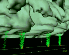 Image by Lee
![[Image: (28K)]](/guides/mtr/svr/modl/line/gifs/torn1.gif)