|
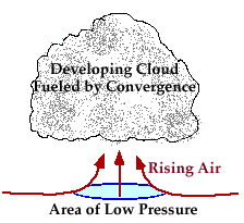
Convergence is an atmospheric condition that exists when there is a horizontal net inflow of air into a region. When air converges along the earth's surface, it is forced to rise since it cannot go downward.
|
Large scale convergence can lift a layer of air hundreds of kilometers across. |
|
[Image: thickening cirrus and cirrostratus at sunset (56K)]
Photograph by: Rauber |
Vertical motions associated with convergence are typically much weaker than the small-scale vertical motions associated with convective processes. As a result, clouds generated through convergence, for example cirrostratus clouds, are typically less vertically developed than convective clouds. |
![[Image: thickening cirrus and cirrostratus at sunset (56K)]](/guides/mtr/cld/dvlp/gifs/cnvrg2.gif)
|
convection |
|
topography |