|
850 mb Discussion
destabilization of the lower atmosphere
The 850 mb pressure level analyses are quite valuable for analyzing
all types of synoptic weather patterns. This level is often just above the
"friction"
layer - i.e. the surface will not, typically, have much influence on wind
direction, wind speed or temperature at 850 mb (about 5,000 feet). Thus
it is often part of the "free" atmosphere, but it is close to the top of
the boundary layer (in many cases 850 mb falls within the boundary layer),
and is often a level where clouds and precipitation occur. The 850 mb
pressure surface, like the 500 mb pressure surface, is a "mandatory"
level; this means that all radiosonde or upper air instruments record
winds, temperature, and humidity precisely at 850 mb. There are a good
deal of existing meteorological analyses and charts available for this
level - so it a convenient surface to analyze our Veteran's Day LES storm.
In lake effect events, the 850 mb analyses are very important in deducing
atmospheric stability, availability of cold air, cold air advection patterns, and wind flow. In
the Veteran's Day storm, the 850 mb pattern is illuminating. One of the
crucial questions prior to the storm was when the lower atmosphere would
become cold enough to support widespread snow instead of rain or mixed
precipitation. -10C is often used as a guideline for LES cases to deduce
where and when it might become cold enough for efficient production of
snowflakes within the LES clouds.
Note, that even with 850 temperatures warmer than -10C, given water
surface temperatures near 10C, there would be a sufficiently large
lake-to-850 mb temperature difference to categorize this event near the
"moderate" category of lake effect snowfall potential. However, 850 mb
temperatures of -6 to -8C are thought to be marginal for the production of
snow in convective clouds which dominate in LES scenarios. Thus, the -10C
isotherm at 850 mb is a reasonable index for predicting where the clouds
are cold enough to support high concentrations of ice crystals and promote
rapid growth of those crystals, while warm enough to still allow for a
good deal of water vapor in the clouds (which is crucial to the growth and
production of precipitation size showflakes).
During the storm, it appears as if the position and movement of the -10C
isotherm at 850 mb coincided roughly with the onset of heavy lake effect
snowbands. That is, the migration of the -10C isotherm south and east of
a region was often coincident with the first appearance of snowfall in the
favored snowbelt locations of that area.
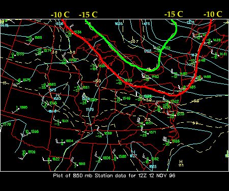
The following images are 850mb analyses from WXP showing
height contours
(that is, the height above sea level at which 850mb of pressure is
encountered above a given point), isotherms in degrees Centigrade, and the
station models (providing temperature, height, dew point, wind direction,
and wind speed) for each upper air station in the domain.
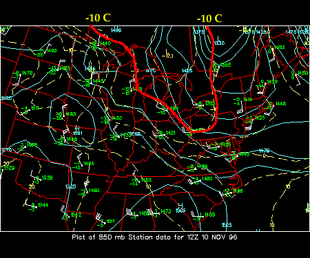
The first 850mb chart is analyzed for Nov 10, 1996 at 12z. The -10C
isotherm is highlighted in red on each map to show its progress east and south
during the first three days of the LES event.
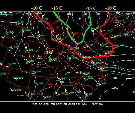
By Monday Nov 11, 1996 the cold air aloft is seeping southward from
Ontario, Canada.
The 850mb upper low which corresponds to the center of coldest
air is near -20C which is unusually cold for this time of year. The
upper low stays roughly at the same latitude throughout the storm;
however, the pool of cold air spreads in the horizontal - especially to
the east making its way to the New England coast by Monday evening.
The destabilizing process in the lower atmosphere takes place rapidly
in LES storms. Remember, the near-surface air over the lake waters is
quite warm and moist at this juncture of the storm. The air is buoyant
and unstable and is easily mixed upwards and "overturned". When this warm
moist air reaches the 850mb level it will be mixed with this air as well.
The properties of both layers will blend together; thus, 850mb air is
"mixed down" to the surface as surface air is turbulently combined with
the air from the lower "free" atmosphere. The net result is a deep layer
of near-neutral air with temperatures falling off sharply with height, and
large amounts of water vapor available for clouds and precipitation.
Likewise, the higher winds (momentum) from the 850mb level are also mixed
down to the surface which can help to steer and increase winds just above
the lake waters; this helps to enhance evaporation into and heating of the
over-water surface air.

introduction
|
|

500 mb
|
|