|
|
. |
Forecasting Near Anticyclones
generally fair weather
A high pressure center
is represented on a weather map by a blue "H"
and air diverges outward from a surface high.
With air moving away
from this region, air must sink from above to replace it. This sinking
motion leads to generally fair skies and no precipitation near the high.

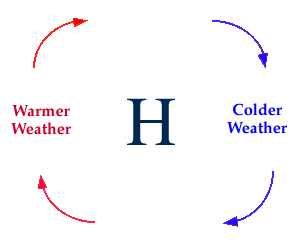
Winds flow clockwise
around a high pressure center
in the northern hemisphere (above).
Temperatures are dependent upon the location relative to the high.
Northerly winds associated with an approaching high are likely to result
in colder temperatures while southerly winds found on the
backside of a high, or once a high has passed through, typically result in
a warming trend.
|
