|
|
. |
Dynamic/Synoptic Analysis - Stability
November 9-14, 1996 in the Great Lakes
1b. Stability:
An unseasonable cold-air outbreak in the middle or late fall is an ideal
setup for LES. Lake temperatures might remain in the 50's (degrees F)
while it
is not uncommon to see air as cold as 20F blow over the lake waters in
mid and late-November. Converting to centigrade and meters, an unstable
atmospheric layer occurs when the "lapse rate" of temperature change with
height exceeds -1C/ (100 meters); in our example the lapse rate in the
first 10's of meters above the lake might exceed -5C/(100 meters)!
Needless to say, this is an extreme instance of surface heating from
below and leads to rapid destabilization of air parcels and strong rising
motions (although these large lapse rates are not uncommon in these
circumstances). However, the destabilizing effect is quickly damped out as
one
moves upward from the lake surface so typical lake-effect snows occur in
shallow layers of only a few thousand meters.
A number of computer "models" of lake effect snow have simplified the
atmospheric structure within an LES system by defining two or three
distinct layers. The first layer is right near the water surface,
perhaps 100m where the environmental air is very unstable, dominated by
turbulent air flow, and
cools rapidly with height; this is called the surface layer. Above the
surface layer is the friction or planetary boundary layer - that is, the
layer of the atmosphere that is influenced by the surface characteristics
of temperature and roughness or frictional elements; this layer is
"neutrally" stratified (i.e. its lapse rate is always near
-1C/(100m) and
is called the "well-mixed" layer since air parcels that might start to
rise will tend to continue ascent, but parcels which might fall will
continue until a layer of different stability is encountered - the end
result is a rapid and efficient overturning of the air in the lowest ~1 km
of the atmosphere (approximately). Above the well-mixed layer is the
"free atmosphere" which is unperturbed by surface
conditions.
During an LES the free atmosphere is cold, dry and often characterized by
moderate to strong stability. Temperatures change little with height and
may actually increase a bit with height (an inversion) - in such an
environment air parcels have a tendency to sink and warm which is called
subsidence.
In the Green Bay sounding shown below, a well-defined mixed layer with a
good capping inversion is evidenced at about 760 mb; above which is the
free atmosphere which exhibits weak static stability until the tropopause
is reached at about 400 mb which exhibits strong static stability. This
is a more typical looking sounding for an LES event.
[Image: Green Bay Sounding 11/11/96 12z (45K)]
The interface between the mixed layer and the free atmosphere is often
characterized by an inversion; the well-mixed layer, through adiabatic
motions and turbulence, has effectively redistributed the surface heat and
moisture
while the free atmosphere is inducing sinking and warming of air near the
buffer between the two.
The discontinuity between these two layers
results in a rapid spike of warming with height which gives a layer of
strong stability and thus acts as an inhibitor or cap to rising air
parcels from below. The height of this capping inversion is a measure of
the competing strengths of the surface heating and convective mixing
trying to weaken and elevate the cap, versus the large scale
cold air flow
(advection) and subsidence trying to strengthen and push the cap downwards.
The models that have employed this scheme show the height of the cap
will increase gradually as one moves over the lake (along the trajectory of
the flow) and will increase sharply as one encounters the downwind shoreline.
|
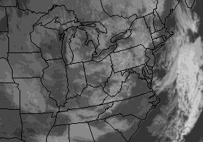
If the cap defines the height of the cloud tops (which is consistent with
observations), the greatest cloud tops will be found just inland on the
leeward side of the lakes. In this visible satellite image,
the formation of clouds is clearly a function of how far the
airstream carries over the lake waters (this shows up well especially in
lower Michigan).
|

Background
|
|

Wind Shear
|
|
![[Image: Green Bay Sounding 11/11/96 12z (45K)]](/arch/cases/961109/adv/gifs/stb1.gif)