WW2010
University of Illinois

WW2010
 
welcome
 
online guides
 
archives
 
educational cd-rom
 
current weather
 
about ww2010
 
index

Archives
 
case studies

Case Studies
 
introduction
 
veterans day snow
 
hurricane andrew
 
4/19 il tornadoes
 
superstorm '93

4/19 IL Tornadoes
 
headlines
 
from the chase
 
the damage
 
how it happened
 
nexrad close-ups
 
data and images

Data and Images
 
introduction
 
composites
 
nexrad images
 
satellite
 
surface
 
upper air images

User Interface
 
graphics
text

.
Weather Data and Images
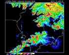
4/19/96 severe weather outbreak

NEXRad Six-Panel
Composites
Surface Analysis
Upper-Air
Analysis
Satellite Imagery Wind Profiler and
Cross Section Data

This section provides access to weather data and images for the severe weather outbreak of April 19, 1996. It was estimated that 30 tornadoes touched down in Illinois alone, with a pair twisters ripping through neighboring Ogden and southeastern sections of our town, Urbana, Illinois. The analysis period extends from 12Z April 19 until 06Z April 20, 1996. Validation times for the images are given in Universal Time Coordinates (UTC).


NEXRad Close-Ups
Terms for using data resources. CD-ROM available.
Credits and Acknowledgments for WW2010.
Department of Atmospheric Sciences (DAS) at
the University of Illinois at Urbana-Champaign.

composites