
|


 |
Polar Orbiting Environmental Satellites (POES) are placed in circular sun-synchronous (see below) orbits and their altitudes usually range from 700 to 800 kilometers, with orbital periods of 98 to 102 minutes. |
| Image provided by: National Climatic Data Center |
POES satellites include: Defense Meteorological Satellite Program (DMSP), Landsat, SPOT and NOAA Polar-orbiting Operational Environmental Satellites (NPOES). The DMSP and NPOES satellites are operational meteorological satellites. Imagery from successive orbits overlay each other, providing global daily coverage from each satellite. Commercial polar orbiters like Landsat and SPOT, on the other hand, are intended for geophysical remote sensing, with an emphasis on high-resolution and multispectral imagery, at the cost of daily global coverage.
POES have meteorological and geophysical importance because of their high-resolution global coverage and well calibrated channels. They are designed to stay in a low earth orbit and reach high latitudes. The POES program began in 1960 with the launch of TIROS-1. Later satellites in the Improved TIROS Operational Satellite (ITOS) program were expanded to capture concurrent multiple-channel data on a daily basis.
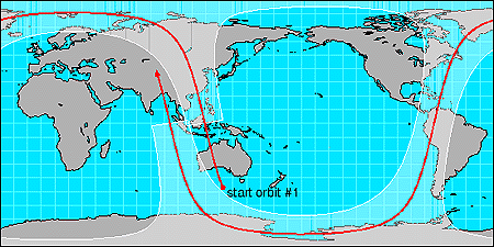
Image provided by: Satellite Coverages and Orbits (NCAR)
The POES orbit (above) relative to the Earth's surface is
sun-synchronous. Its track
is due to a combination of the orbital plane of the satellite coupled with
the rotation of the Earth beneath the satellite.
The orbit is slightly tilted towards the northwest and does not
actually go over the poles. The red path follows the earth track
of the satellite, the transparent overlay indicates the coverage area
for the Advanced Very High Resolution Radiometer (AVHRR) imaging
instrument carried by NOAA/POES satellites. This
instrument scans a swath roughly 3000 kilometers wide.
Text Provided By: Satellite Coverages and Orbits (NCAR)
|
GOES Satellites |
|
dmsp poes |