
|


|
The Defense Meteorological Satellite Program (DMSP) is run by the Air Force Space and Missile Systems Center (SMC). |
| Image provided by: DMSP Homepage |
The DMSP program designs, builds, launches, and maintains several near polar orbiting, sun synchronous satellites monitoring the meteorological, oceanographic, and solar-terrestrial physics environments.
DMSP satellites are in a near polar, sun synchronous orbit approximately 830 kilometers above the earth. Each satellite crosses any point on the earth twice a day and has an orbital period of about 101 minutes, thus providing complete global coverage every six hours. Each DMSP satellite monitors the atmospheric, oceanographic and solar-geophysical environment of the Earth.
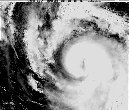
Image provided by: DMSP Homepage
These satellites have capabilities to zoom in close to atmospheric
phenomena (like hurricanes).
Other capabilities
of DMSP satellites include the detection of: lightning, biomass burning,
aurora, snow, ice and even city lights.

Image provided by: DMSP Homepage
The image above reveals where the lights are in the US when the
sun goes down.
The data from the DMSP satellites are received and used at operational
centers on a continual basis. The data are sent daily to the
National
Geophysical Data Center (NGDC) and
Solar Terrestrial Physics
Division (STPD) for creation of an archive.
Text Provided By: DMSP at NGDC
|
introduction |
|
noaa poes |